flanagaj
-
Posts
1224 -
Joined
-
Last visited
-
Days Won
2
Everything posted by flanagaj
-
I somehow managed to dig the trench for our water connection in slightly the wrong place and put it bang centre of the new proposed access. As a result I want to move it < 2 metres, but as the trench was inspected and signed off, I didn't really want to incur further costs, when the new connection point makes absolutely no difference as it's a straight lane and they have charged me 2k for a road closure as it is. Should I come clean or just dig a new trench and pretend nothing has changed?
-
A 1.7 tonne machine is still going to cost ~ 10k
-
There's an old 1000 gallon septic on site that at some point I need to decommission. It looks like an onion shaped fibreglass tank, but I'll need to get it emptied first to be certain. I've got a huge pile of rubble that I was contemplating using to fill it in and then was going finish the top off with concrete. I suppose that I need to also smash a hole in the bottom to ensure any water ingress drains. Does that work? I am contemplating using the tank for a knock up make shift outdoor toilet and sink. Will save on portaloo hire.
-
Because I don't want any ambiguity regarding how much of the verge is owned by Hampshire CC. According to the diagram they provided, it looks like it is 2m, but that seems a lot. If I request the condition is removed, Hampshire CC Highways will either agree with our observation and say "Yes, we own all of the land in the splay" or no, the condition cannot be removed as we don't own the land in the required splay.
-
Package treatment plant infiltration depth?
flanagaj replied to flanagaj's topic in Waste & Sewerage
I thought the drainage field depth was to do with the waste being in the aerobic zone of the soil, hence why they state no more than 900mm deep. I am sure Graf make mention of this depth, but I could be wrong. -
So I'm slightly confused on this. I've just read Part H regs and only see reference to a minimum depth "distribution pipes should be laid at a minimum depth of 500mm below the surface", but I've also seen mention of it being a maximum depth of 900mm from other sources, but Part H makes no mention of a maximum depth? The reason I ask is that if we stick with the regs of having the PTP at 7m from the house and site the drainage field where we want it (15m from house), the total run from the first stack at the house is 32m. If I go 1/80 fall for soil pipe to PTP and then 1/200 for PTP to drainage, it basically equates to 304mm. Which might make the soil pipe depth at the house ~500mm.
-
Exactly. I am going to put a case forward that the condition be removed, especially as the responsibility for keeping the splay in line with the Highway condition lies with Hampshire CC alone.
-
I did that and according to the shading on the document I posted, it extends 2m back from the road verge. If that is correct (seems a lot), then the visibility splay is within the bounds of the verge owned by Hampshire CC and therefore I don't need to be concerned as any hedging that resides in that space can be asked to be cut back. I have asked the architects to double check my conclusion and if it is correct, ask Highways to remove the condition from the PP.
-
Yes. Great idea. Hadn't considered that option. Thanks
-
The told me the scale is 1:1250 but on an A4 printed sheet that scale will be very difficult to get an accurate measurement. I did consider a traffic survey, but unfortunately, there are local residents who drive far too fast down the lane. When I drive down it 20mph is fast enough. So not sure a traffic survey would go in our favour.
-
I still think it will be tight.
-
The new entrance is as below. I have just calculated the distance from the road to the splay at the point we cross the neighbours boundary and it's 1.8m. Looking at the image below 1.8m is not possible.
-
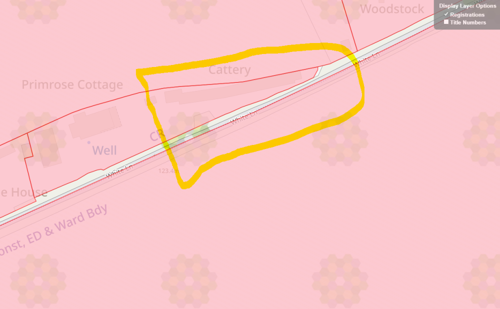
Yes. I think a trip up to the site is required this weekend to mark things out. Although the road is unclassified and theoretically a 60mph road it's a non through lane and they have requested a 43m splay as is required for a 30mph road. Interesting that yours was to the centre of the carriage way and ours was to the road edge?
-
I don't want the original access. Surely before embarking on a scheme for a client, they should have done the necessary due diligence to ensure access is viable? I did this yesterday and the result is below (glad I paid for the 20 day turnaround and not the express 5 day turnaround. Got the results in an hour and saved > £200). The tricky part is translating the splays across the area in pink to deduce whether the splays sit outside the pink. I suspect they do, given that you have to measure back 2.4m from the edge of the verge for where the splay starts. I can do some basic trig to work out the distance of the splay when we cross to the neighbours boundary.
-
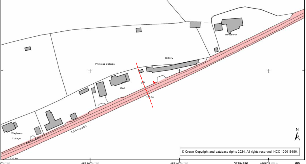
So I have purchased the report and it does show Hampshire CC do own the section of verge. I sent the plan showing this to the architects to ask them whether the visibility splays do sit within the HCC owned map and none of the splay crosses land owned by the neighbour. A highway consultant (was very helpful) informed me that so long as the visibility splay sits within HCC owned land, then any hedging that sits within that can be ordered to be cut back via a enforcement notice. This then means that we don't have to worry about the condition as it can always be resolved, where as the visibility splay crossing the neighbours land / hedge is outside our control. I am also requesting the architects raise the issue of the visibility splay being requested to the edge of the carriageway, as it is an unclassified road which is only 7ft wide, so definitely single lane. This apparently means the visibility splay is taken to the centre of the carriageway and not the edge. I have told the architects to push to have the condition removed.
-
Ok, thanks. I need to find the corresponding link for Hampshire Council.
-
Bit late now. We've spent 5k with them and the planning officer is about to complete the application.
-
The plot already has granted PP and the access for that application is shown on the second image. The access already exists and was the entrance to the old cattery business. As to the boundary not going to the road edge. Our solicitor never flagged that. I just checked on Land Registry and it appears to not be owned by anybody and I think it must be owned by the council. This would have come up in searches if there had been an issue with access and ransom strips. As no development has happened on the lane in 40 years or more, there won't be any chance of finding anything which might help the case. Worst case scenario, we will have to leave the access where it is.
-
But a quick look on land registry suggests the boundary is not up to the road. Where as on the south side the farmer seems to own half of the road as well. This could be a land registry display issue.
-
No. The residents cut the verges and the local farmer cuts the hedgerows
-
I have gone back to the architects and told them that it's their mess and they need to resolve it. It is frustrating that they have imposed this when the current entrance does not meet said requirements either.
-
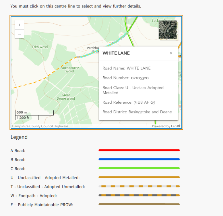
So I have just manged to find out it's classification
-
I am not sure if it is classified. How can I tell? It's a no through lane, that does have a council named sign at the entrance, so I assume it is.
-
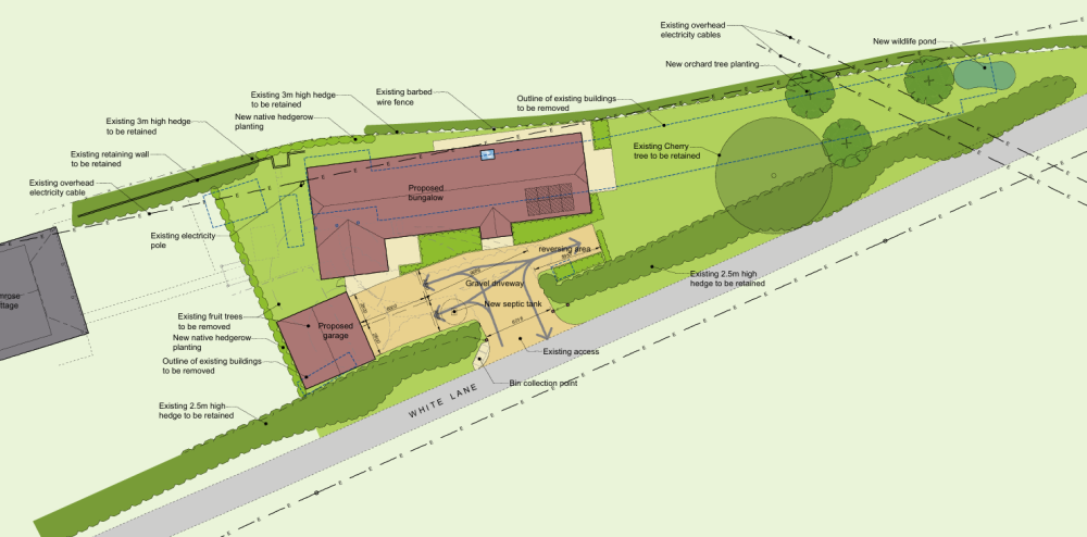
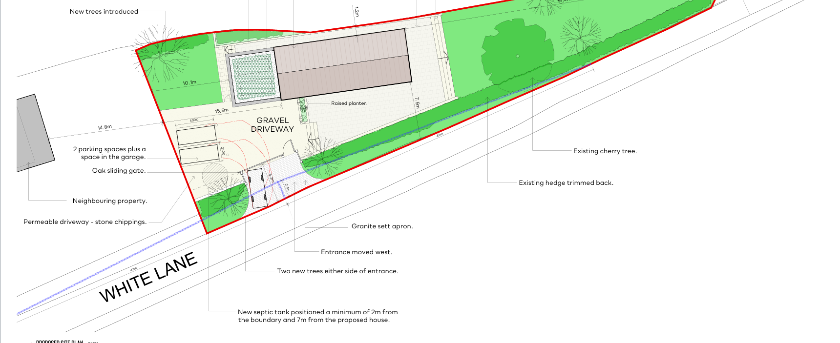
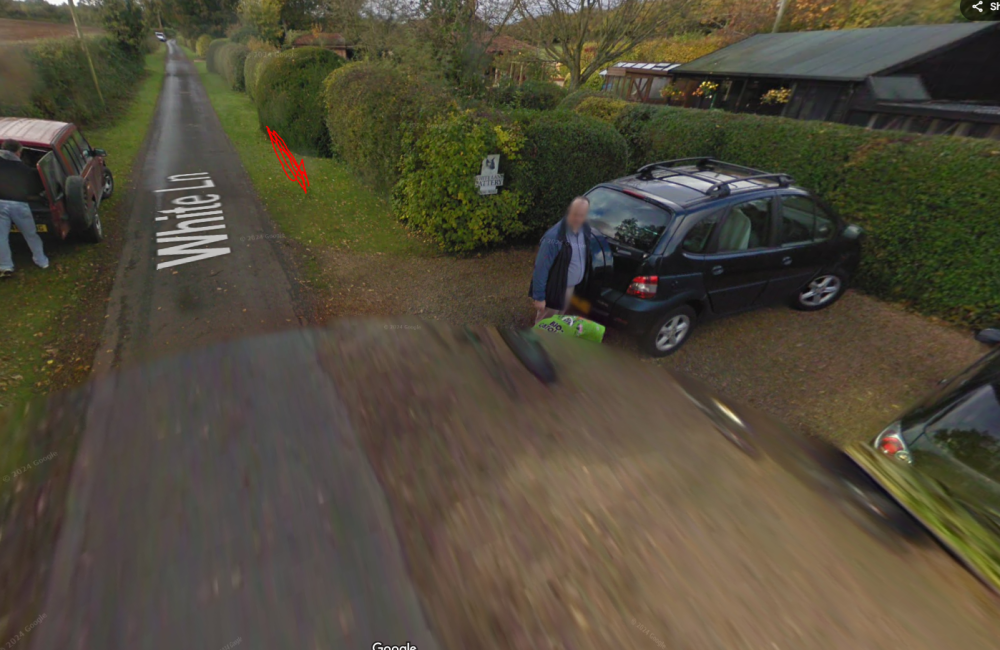
Just to add. This is what the architects have come back with. One would think that before designing a house and submitting the application with visibility splays considered. I feel that it's their screw up and they've seriously messed up. "This could be an issue.. The previous permission did not have this 1.0m high clear sight line requirement, but then the access was not moved west. To make the current scheme work we have to move the access west, which brings it nearer to next door, making the visibility splay to the west potentially harder to achieve. (that said the last consent also had a bin store blocking this view although I guess that may have been 1m high only.) To be sure this isn't a potential problem we need to know some measurements as to the extent of next doors hedge and whether it obscures our 43m visibility splay as you look right - from 2m back from the highway edge - from the centre point of our proposed new access. The photo below shows that there is some grass verge to help here, but we need to check whether this is sufficient to comply with the suggested condition. If it's not, the choices are to do nothing, accept the consent and assume it'll never be checked or challenged, or to instruct a qualified highway engineer to make a case that the new access, and what can be seen to the right is adequate for this very lightly used single carriageway lane. I can suggest a name in this connection if required. It would be helpful as a start, if you could plot some dimensions when you next visit to ascertain if we do have an issue to address here. Hope that makes sense."
-
So the architects moved the proposed entrance of our house slightly westwards to that of the granted planning permission. As is clearly visible from the blue line, it cuts directly through the neighbours hedging and they won't agree to us removing said hedging to meet the condition that they have attached (see below). What is strange, is that the granted planning application shows the visibility splay to be nowhere near as wide as what highways have mandated this time. "Before the development is brought into use, the means of vehicular access to the site shall be constructed in accordance with the approved plan (Drg No.24-WLC-PA-10) and no structure, erection or planting exceeding 1.0m in height shall thereafter be placed within the visibility splays shown on the approved plans." The existing entrance is shown below and Highways didn't mandate any conditions (they did so a site visit), and they haven't this time. It's also a no through lane. I obviously don't want to build a house that cannot be lived in because the condition cannot be satisfied.