Raine
Members-
Posts
43 -
Joined
-
Last visited
Personal Information
-
Location
South east
Recent Profile Visitors
The recent visitors block is disabled and is not being shown to other users.
Raine's Achievements

Member (3/5)
3
Reputation
-
Things were so much easier back in the old days of gas boilers and wet rads. The sparks did the electrics, the plumbers did the heating, and there was a tiny bit of task overlap to wire in the boiler. These days, you could employ separate specialists for solar, roofers (for installing in-roof PV), ASHP, UFH, MVHR, batteries and EV chargers. As well as sparks and plumbers! Not to mention the overlap with main contractor works (I’m planning a single main contractor for superstructure up to watertight shell). The system needs to be designed holistically, and I don’t have the patience this time round to study and do it all myself, so I want someone else to do that. I also have an added factor that I’m also doing major structural changes and refurb to the existing 1930s house on the site, and am considering adding an ASHP with upgraded wet rads. I’ll want the same contractors doing both houses. I don’t have limitless funds so I need to be mindful of keeping costs in check. What do people tend to do for heat & power these days? One-stop-shop or separate contractors? If separate, which contractor would do the overall design? If one-stop-shop, is there anyone you’d specifically recommend (or avoid)?
-
A little hogmanay amusement! I'm reading through a couple of build specs that I found online, to see if there's anything I want to pinch for my spec, and came across this in one of them, which is clearly an amusing test to see if the contractors actually read the spec, and I thought I'd share it!! "Site Meetings The Architect will hold regular site meetings to review progress and other matters arising from the administration of the contract. Contractor to provide tea in blue china mugs on yellow place mats, accompanied with Scottish shortbread." 🤣 🤣🤣
-
1st floor beam and block v timber floor Price comparison
Raine replied to Canski's topic in Floor Structures
Thanks @Canski. Did you install wet UFH with the posis? If not, do you have no heating on that floor, or rads / elec mats? Good point on the U values too. Something for me to bear in mind as the design fleshes out and I get SAP calcs done. I have spans of ~6m so solid timber is a no go, I assume. -
1st floor beam and block v timber floor Price comparison
Raine replied to Canski's topic in Floor Structures
Resurrecting this thread as I have a similar decision to make. @Canski, did you go for beam & block or posis in the end? Do you have any cost comparison calcs or anything else that may be helpful in making such a decision? -
Resurrecting this thread as I have a similar decision to make. @iMCaan, did you decide on MF or battens in the end?
-
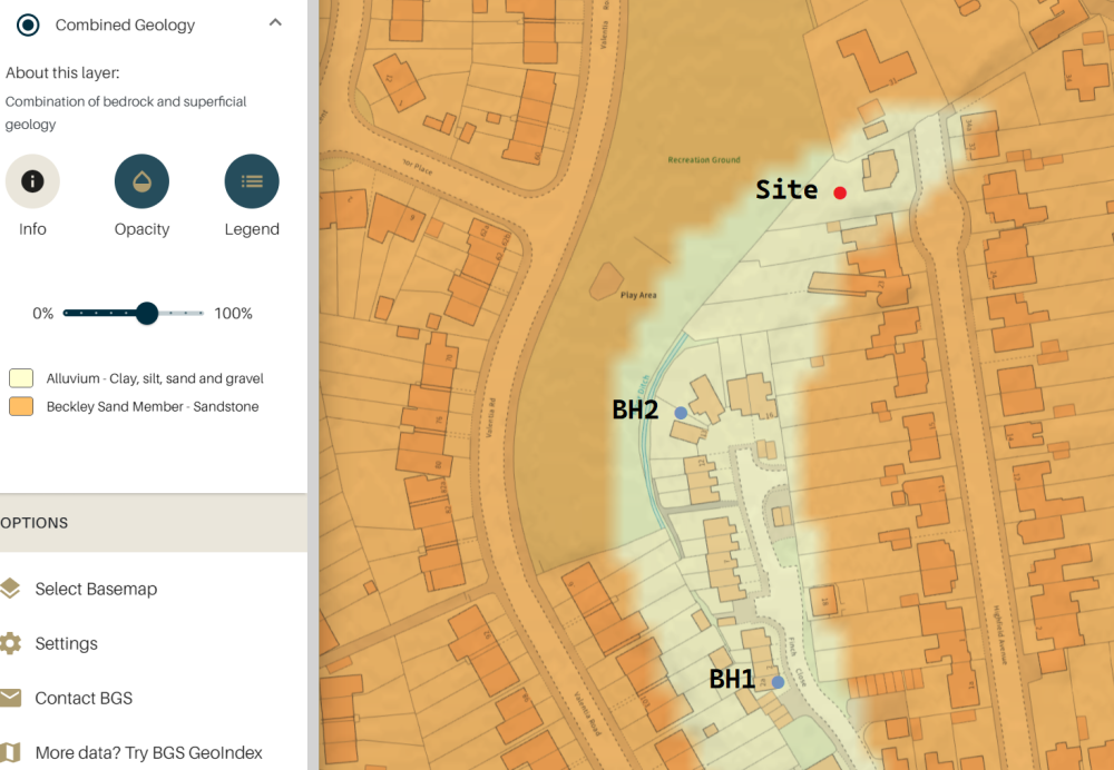
Yes and no!😞 The houses in the road were built in the 1930s, and all look good and solid. However, as you can see from the BGS map, the ground conditions on the site are likely quite different from the rest of the road: The neighbour immediately to the south (which looks like similar ground, according to the BGS map) did a rear extension a couple of years back. I have asked them what foundations they had, but they've not got back to me, and I suspect they won't. It's only single-storey anyway, so won't have anywhere near as much load as my two-storey + rooms in roof. My existing house was built in the 1930s and is good and solid with no sign of movement. Attached to the house is a 1970s two-storey side extension that has a distinct DIY feel about it, which has moved significantly away from the main house (I got a big discount on the agreed purchase price because of this). The exact cause of this movement isn't yet known. Here's where I'm at with that: Previous owners claim this was settlement and hasn't moved for years (they would say that though!). Massive ash tree ~3m from the extension felled when I bought the house last year. Trial pit dug exposing the extension foundations. Bottom of concrete @ 1.2m depth Very large tree roots pushing up against the bottom of the concrete Standing water at 1.4m depth We suspect the extension hasn't been properly tied to the main house, which I am hoping to see when we rake out the crack and get a proper look. I am hoping that the movement will stop now that the tree has been removed, and when the extension gets tied properly into the main house (Helifix). Worst case, the extension needs demolishing and rebuilding. 😞 Hmm, maybe I should get the helifix done now rather than waiting, and see what happens over the next few months? If I get that Helifixed and the foundations are still insufficient, where am I likely to see the issue reappearing? At the helifix location, or cracks elsewhere in the extension?
-
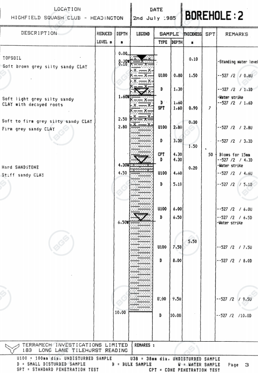
There is a former underground stream which has now been replaced(?) with a Thames Water storm drain. I don't know how much of the underground stream still remains in the wild, but I was expecting to see water here. I presume that pushes us more towards piles than trenchfill? I guess hard sandstone would give a high SPT number thought, right? But it's a very thin layer (and may not even be present at my site), with stiff sandy clay below, to the bottom of the borehole. I was hoping I could have <2m trenchfill (but I've budgeted for 5m-deep piles) but if the ground is soft down to 2.5m, would that make piles more economical? I heard that anything deeper than 2m generally works out cheaper to have piles than trench?? Would the stiff sandy clay provide sufficient bearing for a pile, or would I need to go deeper and find something even firmer (which would likely be deeper than 10m, based on the local borehole)? Or is it a case of it might be sufficient, subject to calcs? Friction piles would be the thing here, right?? In which case, I presume the amount of friction needed would be based on the weight / load per pile, and that would then inform the required pile depth?
-
Still pondering this. I know the local borehole that I mention above (85m away) is unlikely to be 100% representative of my ground conditions, but it's the best info I have to work with at this theoretical stage, so I'd like to be able to understand and interpret it. I think it's showing me this - have I understood correctly? § 0.1m topsoil § 1.5m of soft brown grey silty sandy clay (to total depth 1.6m) § 0.9m of soft light grey silty sandy clay with decayed roots (to total depth 2.5m) § 0.3m of soft to firm grey silty sandy clay with decayed roots (to total depth 2.8m) § 1.5m of firm grey silty sandy clay (to total depth 4.3m) § 0.2m of hard sandstone (to total depth 4.5m) § 5.5m of stiff sandy clay (to total depth 10m (bottom of borehole)) Is there anything else noteworthy in that borehole report?
-
Yes, I will be getting a warranty, but I haven't organised that yet. My previous self-build warranty providers were happy to accept SE foundation designs and BCO sign-off, but I guess not all of them will be. Speaking of which, does NHBC Solo no longer exist?? (I am aware that there are other providers, but that was a big one) Thanks for this info Declan, I didn't know any of that. I just want to find the least-cost route of getting foundations that are good enough, without being over-engineered, and of course the SE and warranty providers both have a vested interest in me taking the opposite route. It's hard to navigate.
-
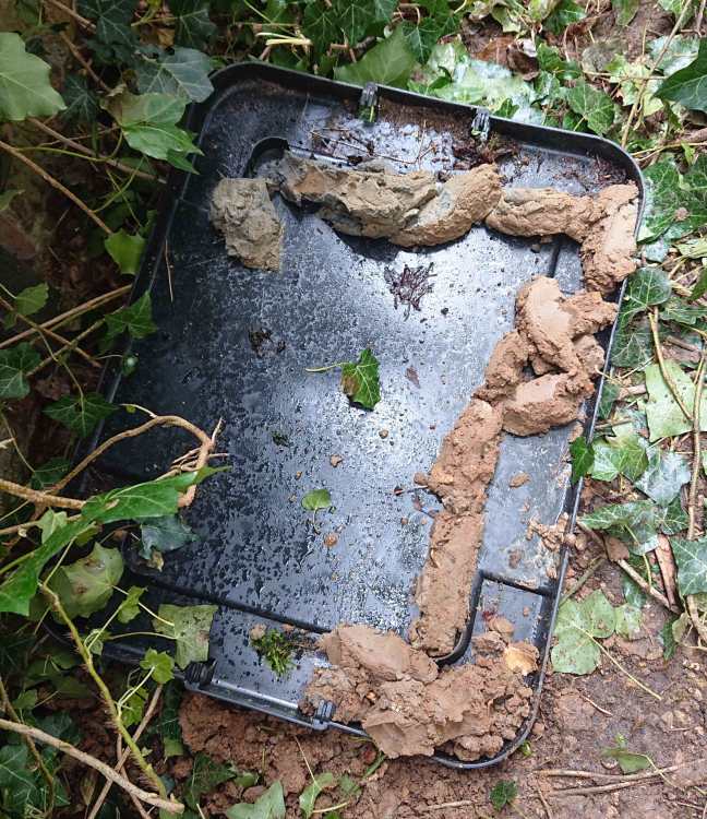
Thanks both for the replies. So I get holes dug or bored - then what? FYI, I already had a trial pit dug while I was purchasing the house, at a corner of the existing 1970s extension (the house itself is 1930s). The hole revealed 525mm (7 courses) of below-ground brickwork, on 675mm of concrete. I had a 50mm hand auger done to 3m depth at the same time, which filled with water to about 1.4m depth in the couple of hours that the hole was open. The guy who dug the trial pit kept the soil that you see in the below pic. Should I send that away for analysis? Would that be enough? Trial pit was on the right-hand side of the plot, and my plans also include new foundations about 17m away on the left hand side of the plot. I also have a hole currently open on the other side of the site, which was needed for a soakaway test, but that's only to 500mm depth. I could dig it out further, but again, then what? Photo shows the drier, shallower-depth soil at the bottom of the picture, and the wetter, deeper soil at the top of the picture.
-
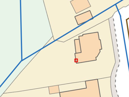
Sorry, should have researched more before posting the above! I found this thread: https://forum.buildhub.org.uk/topic/36759-soil-and-ground-investigation-options, and @OwenF's advice on the BGS maps. As with the OP on that thread, I also didn't know this info was publicly available. Thanks so much for this info!! There were two nearby boreholes, the nearest being ~85m away, and on similar ground by the looks of the map: Looks like alluvium to a depth of 4.3m, then a thin layer of sandstone, then stiff sandy clay, right? Borehole 1 is similar but further away. I'm concerned about ground water, as parts of the back garden get waterlogged after heavy rain, but I'm not sure how to interpret the water data shown in the borehole record? The former underground stream (now converted to Thames Water storm drain) that I mentioned above is located here: Would this type of ground generally require piles, do you think? Or standard trenchfill + beam & block? It’s been a while since my last new builds (2011), and perhaps things have changed since then, but neither of them (both of which were on clay soil) required full Ground Investigation Reports, either for the structural design or for the warranty. In fact, I didn’t even need any geotechnical analysis done – the building inspector just examined the open trenches and asked for us to go down a bit further in one corner. I'm perplexed as to why all the SEs I've spoken to so far seem to be being so very cautious by either saying that I'll need Ground Investigation Reports, or piled foundations, or both. I'm on a tight budget and can't afford to throw money away if it's not necessary. 😞
-
I've recently had planning granted for a new build + mods to existing house, and am trying to find a structural engineer. Some of them are asking for ground investigations to be completed before they will quote, as this will dictate what type of foundations they need to design, and therefore the amount of work they'll need to do. The geological drift map shows alluvium on one side of the site (underground stream, now converted to Thames Water storm drain) and clay on the other side. I'm now stuck, as I don't know precisely what investigations to commission and how to scope these. What would you guys do? Ask the SEs (who are still at presales stage) to advise? Contact some geotechnical companies and ask them? Something else??
-
If anyone is in need of a good ecological surveyor in the area between Birmingham, Cotswolds, Milton Keynes, Oxford, Swindon, Worcestershire & Gloucestershire, PM me. I found a good one.
-
- 1
-

-
This is from the doc named "baseline": This is from the doc named "as proposed": I was expecting either one or two TERs (one for 2022 Regs and possibly also one for the Planning requirement of 40% improvement) and one DER. There are two TERs, but the lower figure isn't a 40% improvement on the higher figure, so I don't know what they are. And there are two DERs, and I have no idea why, other than I presume the lower figure is my proposal, as he said it passes. Is it just me, or is this hard / impossible to figure out what's what without being told? I know you all say "forget it and move on", but I'm the type of person who likes to understand things (not every detail, but at least to some extent), and also, I might want to down-spec a bit to save costs in some areas.
-
All understood, but I need to include the relevant figures in my energy statement, which I can't do if I don't know which is which. Maybe you're right though, and I should stop trying to do it "right" and just cherry-pick the most favourable figures at any point in the design and build process and go with those. In the meantime, I'll look on Google for some beginner's guides to SAP and see what I can find to read in my spare time.


