BigBub
Members-
Posts
16 -
Joined
-
Last visited
Personal Information
-
Location
UK
Recent Profile Visitors
The recent visitors block is disabled and is not being shown to other users.
BigBub's Achievements

Member (3/5)
9
Reputation
-
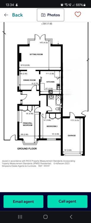
From the original floorplan that OP posted which shows that the garage extends beyond the front of the house and therefore if the extension joins to the garage then it would be beyond the principle elevation. Why is everyone so sure that the garage is an original part of the house for the proposed extension to be under rear and side extension rules? @vik2001 do you know if the garage is an original part of the house or a later addition?
-
Just to make it clear, what you are building is a side extension, unless the garage is an original part of the house or was there before 1948 in which case it would be treated as a rear extension. Planning permission is required for what you are building for two reasons: The extension joins on to the existing garage that is to be converted and as the garage extends out beyond the principle elevation of the house, it does not meet PD rules. As the side extension is within 2m of the boundary, the height of the roof eaves is limited to 3m under PD.
-
From my experience, the Planning portal calculator tends to always get the fee right, assuming you've selected the right categories. Is the new house and the house to be altered on the same site, within the same red line boundary? From my understanding, when an application falls within 2 categories, you will usually pay the higher of the two fees, rather than a combination. I would definitely be directing the council to the mixed development flowchart, and if they still did not agree, I personally would appeal for non-determination after 8 weeks.
-
incorrect scale within submission of .pdf drawing to Planning
BigBub replied to Post and beam's topic in Planning Permission
Open your document in Adobe Acrobat and go to File -> Properties. You should see the Page Size of the document here. You now need to work out the scale factor you need to change from the current paper size to A1 (if it is currently 8.5" x 11" then you need to scale it up by 300.9% to get it to A1 dimensions). Then go to File -> Print and choose Adobe PDF as the printer and set the page size to Custom Scale: 300.9% and print the plan to the now correct paper size. When using the Measuring Tool, you would need to set the scale ratio each time. The exception to this is if your document had an embedded scale, which you normally get when you create a plan in AutoCad etc. -
You've effectively had permitted development rights for extensions (class A), roof alterations/additions (class B and C) and outbuildings (class E) removed. The space around the house is very small so it makes sense why they would not allow for you to add any extensions or sheds/outbuildings without applying for permission.
-
Actually, the 4-year rule has recently been removed from legislation. Now all unlawful developments, including householder related developments, have to go unnoticed for 10 years to then be exempt from enforcement action.
-
I actually remember reading about a case similar to this not too long ago. I have managed to find an article which covered it: https://localgovernmentlawyer.co.uk/planning/318-planning-features/47278-incorrect-plans-a-strict-approach The application was granted on the condition that the development complied with the plans. As the article mentions, the plans showed the development property as having a lower ridge height than the neighbouring properties. But, if it were built to the approved dimensions, the development property would be higher than both, in one case substantially. In the judge's view the plans showing the relationship to the neighbouring properties were not simply illustrative; they were a material part of the planning decision. The plans should have been capable of implementation and they were not. As a result, the whole permission was not capable of being implemented.
-
You probably want to look in to a Prior Approval application under Class ZA - Demolition of buildings and construction of new dwellinghouses in their place: https://www.legislation.gov.uk/uksi/2015/596/schedule/2/part/20/crossheading/demolition-of-buildings-and-construction-of-new-dwellinghouses-in-their-place
-
Garage Development in Greenbelt/Conservation Area
BigBub replied to phykell's topic in Planning Permission
I agree with @kandgmitchell. If you look at the current appeal timescales (https://www.gov.uk/guidance/appeals-average-timescales-for-arranging-inquiries-and-hearings) you'll see that the average Householder appeal is taking 22 weeks at present. -
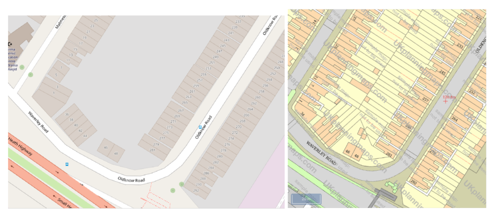
Whilst you could use Open Street Maps to produce a site location plan, many Council's will require the location plan to use an up to date OS map. The OS maps are much more accurate and detailed than Open Street map, and will also generally show the site boundary which is not really shown on Open Street map. See comparison picture. There is the INSPIRE Index Polygons spatial dataset which you can download and add on to QGIS on top of Open Street maps though which helps show site boundaries based on freehold property registrations.
-
Submitting two alternative applications is actually a recognsied thing. Alternative developments on the same site If different proposals for full or outline permission, or for approval of a reserved matter, are all submitted simultaneously, by or on behalf of, the same applicant, a concession is available. The fee should first be calculated separately for each alternative for which permission is sought. The total fee payable is then calculated by adding to the highest of these separate amounts half the sum of the other separate amounts. Please see paragraph 10 of Part 1 of Schedule 1 to the Town and Country Planning (Fees for Applications, Deemed Applications, Requests and Site Visits) (England) Regulations 2012, as amended. Paragraph: 033 Reference ID: 22-033-20141017 Revision date: 17 10 2014
-
What was the specific reason for invalidility? I've seen plenty of councils accept Land Regisitry title plans as site location plans. I've also used UK planning maps and a 1:1250 site location plan PDF from them meets the requirements. If the issue is with the block plan then it usually needs to be at a scale of 1:200 or 1:500 and should show the proposed location for the heat pump.
-
Since it looks like your property was built from a division of land from the property outlined in blue, I would check first that PD rights weren't removed.
-
It would be worth checking if your LPA offer a duty planning service. Some will offer advice over the phone or with an in-person meeting and can give informal advice on your proposed development/drawings. There is no charge for the duty service, but not all councils provide it.
-
Definitely try an appeal, there isn't much to lose. If you decide not to appeal then you could also look in to making a complaint with the local government ombudsman, although they can't change the outcome of the application, they can force the council to pay a financial remedy if they deem you were given any of the following: inaccurate information about procedures or planning law misleading advice in advance of making an application, or no or an inadequate response to correspondence about your development proposals before an application is made or determined. https://www.lgo.org.uk/make-a-complaint/fact-sheets/planning-and-building-control/how-your-application-for-planning-permission-is-dealt-with


